Lifestyle

Lifestyle

Lifestyle

We will be providing weather updates on Tropical Storm Debby and the impact we may see in our area. The Augusta area is still under alert with more rain predicted, especially in the southeastern counties in our region.

Thursday, August 8:

On Thursday, the CSRA could see more rain as TS Debby pushes back toward land. This means the flood threat remains, with a flood watch continuing for areas along and south of I-20 into Friday morning. An additional 1 to 3 inches of rain is possible, though the heaviest rainfall is expected across the southeastern counties in the CSRA. According to WJBF, a cold front will push Debby out of the way, bringing fewer showers and storms on Friday. The weekend should be drier with temperatures warming back up to the lower 90s for the highs.

In Screven County, the Emergency Management Agency has issued an alert to residents in the Lake Eureka area. The dam is in danger of failing, which could lead to more flooding. Residents are being asked to evacuate. If you need a place to evacuate, the shelter location is the Screven County Recreation Department at 1605 Millen Highway in Sylvania.

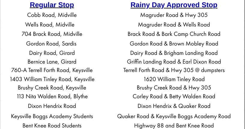
Burke County Public Schools and departments will resume normal operations today, but due to heavy rainfall, some roads are immpassable for school buses. If your road is closed or impassable, don’t risk your safety. Your child will be excused. You can also contact the Transportation Department at 706-554-2859, with dispatchers available starting at 5:30 a.m.

Here are the rainy day approved stops:

Rainy Day Approved Stops

  • Current Delays and Closings

    Government: 

    • There are currently no closings announced at this time.

    Schools:

    • Jenkins County Schools: Closed until Monday, August 12th.
    • Emanuel County Schools: Closed Tuesday, August 6th. A decision for Wednesday will be made later.
    • Richmond County Schools will operate on a normal schedule on Tuesday, August 6. The school system will continue to monitor reports from the National Weather Service.
    • Burke County Schools will be closed Tuesday, August 6. Employees, including twelve-month personnel, are not required to report to work. All students are being provided with Learn from Home materials. A meal for Tuesday will be sent home.
    • Aiken County Schools will have a 2-hour delayed start on Thursday, August 8th for Busbee Elementart, Corbett Middle School, and Wagener-Salley High School. School officials say they will post any changes to the district’s regular schedule at acpsd.net. After school activities are cancelled district-wide.
    • Screven County Schools are closed the rest of the week.
    • Bamberg County Schools are closed on Thursday, August 8th and will make a decision about Friday by midday Thursday.

    Other:

    • National Night Out, sponsored by the Aiken County Sheriff’s Office. Postponed until August 20 from 4:00 until 8:00 pm at Riverside Park Activity Center in North Augusta.
    • The City of Grovetown has announced Liberty Park will serve as an emergency shelter, should there be any road or lane closures there.
    • National Night Out at Fort Eisenhower Tuesday, August 6, has been postponed.
    • Aiken Park Recreation and Tourism facilities will close at 5 pm Tuesday.
    • Lock And Dam Boat Ramps and Boat House Ramps are closed out of an abundance of caution.
  • Resources

    During major storms, it’s important to stay alert and up-to-date. Make sure you have a way to access information even if you lose power.

    Weather alerts: Residents are encouraged to stay up to date on the potential threat of severe weather by signing up for the Augusta Emergency Management Agency’s severe weather and hazardous conditions alerting system. Details HERE.

    Shelter: If you’re in need of shelter due to evacuation, the American Red Cross may be able to assist. You can find open shelters on their website HERE.

  • Impacts in the CSRA

    Tropical Storm Debby has brought heavy rainfall across many areas in our region. This has led to some roads being washed out or impassable. Many dirt roads have been impacted the most.

    Burke and Jenkins Counties have seen more than 9 inches of rain in some areas. This caused Tom Bargeron Road in Sardis and Joe Waters Road in Millen to collapse.

    In Screven County, the Lake Eureka Road Dam is in danger of failing. Residents are being asked to evacuate.

  • Hazards With Debby

    A flood watch is in effect for the CSRA and Midlands from Monday at 12 noon until Thursday at 8 p.m. While the storm has weakened to a Tropical Storm, there are still risks that come along with the heavy amount of rain and strong winds.

    Wind: Strong winds could cause some issues including power outages.

    Flooding: There could be 4-8 inches of rain, with isolated higher amounts. The heaviest amounts are expected in the lower counties in the CSRA and the Midlands this afternoon through Thursday morning. Excessive runoff could result in flooding of rivers, creeks, streams, and other low-lying, flood-prone locations. Street flooding is also possible.  

  • Wednesday, August 7:

    The heaviest rain due to Tropical Storm Debby was seen across the Southeaster counties. Several inches of rain fell throughout the day on Tuesday. The heavy amount of rain has lead to flash flood warnings. The center of the storm was located near the coast, which led to some northwest areas to see significantly less rain. TS Debby is pushing offshore, with some improvement to our weather conditions for Wednesday. There will still be potential for some rain fall today, mostly in South Carolina. Threat of flooding is still an issue. By Thursday, Debby is expected to push back inland, leading to more rain in our area from the outer bands of the storm. This means the threat of flood will remain. The Flood Watch along and south of I-20 will remain in place through early Friday. An additional 1 to 4 inches of rain may be possible. For now, the weekend is on target to be much nicer and drier as TS Debby moves northeast. It won’t take long for the temperatures to return to the 90s.
  • Tuesday, August 6:

    As of Tuesday morning, we’ve had light to moderate rain from Tropical Storm Debby, but according to WJBF, the storm will continue to produce heavy rain for most of the day today. Flood watches and flash flood warnings remain in effect Tuesday through Friday. As of 8 a.m. Tuesday, the National Hurricane Center is predicting TS Debby to move offshore of the Georgia coast later today, but major flood threats are still a possibility in portions of Georgia, South Carolina, and North Carolina over the next few days. *The National Weather Service – Columbia has issued a flash flood warning for Burke, Emanuel and Jenkins Counties from Wednesday evening to early Saturday morning. At 6.0 feet, the access road into the River Bluff community in Midville floods. The lower portion of Johnson Road near Herndon is also flooded. At 2pm today (Tuesday), the stage was 5.2 feet. The river is expected to rise above flood stage Wednesday evening to a crest of 6.2 feet Thursday evening. It will then fall below flood stage early Friday afternoon.
    https://twitter.com/NWSColumbia/status/1820781021996163330
  • Monday, August 5, 2024:

    As of Monday morning at 6 a.m., WJBF says we are under a slight to high risk for excessive rainfall later today through Wednesday. Northern counties are estimated to see around 1 inch of rainfall, whereas, southern counties could see 4 to 8 inches of rainfall. Winds from the East will be 5 to 10 miles per hour. The winds will increase Tuesday and Wednesday to 15 to 20 miles per hour, with gusts up to 40 miles per hour. The National Weather Service in Charleston is alerting to potential for catastrophic flooding mid-to-late week.

Sign me up for the Kicks Country email newsletter!

Become a Kicks VIP today and get access to the latest news on your favorite country artists, plus insider info on upcoming concerts, events, giveaways and more!

*
*
By clicking "Subscribe" I agree to the website's terms of Service and Privacy Policy. I understand I can unsubscribe at any time.